San Mateo County Genealogical Society's Blog featuring society events, projects, meeting notes and other items of relevance to genealogists.

Wednesday, December 2, 2015

San Mateo County Cemeteries: Sunset View

 Cemetery for the Paupers
and the Indigent of San Francisco
 Colma, California

Russ Brabec has authored another great treatise on San Mateo County cemeteries. This one covers the creation and demise of Sunset View Cemetery which was the replacement for pauper burials when City Cemetery (Golden Gate) was closed to further burials.

You will find a well researched article that includes newspaper articles, maps, and a good share of controversy including probate problems and undertaker wars.  Below is the table of contents, click on the link to read the entire publication.

SUNSET  VIEW  CEMETERY

CONTENTS

Part  I -  The Early Years

Part II - The Cause

Part III - The Problem

Part IV - The Participants

Part V - The Result

Part VI - Epilogue

Lot Maps 1899 – 1961

1992 Parcel Map


Tuesday, December 1, 2015

SMC Families: Guerrero


Francisco Guerrero y Palomares 

Born in 1811 in Tepic, Mexico(1), Francisco came north in 1934 as part of a colonizing party that rode from Mexico to Mission Dolores.(2)  Perhaps he was attracted by the promise that he would be able to obtain a piece of mission land by filing a claim with the governor in Monterey citing his military service.  To receive that grant he would be required to draw a diseno (sketch map) of the land he wanted and build an adobe on the granted land.(2)  Over the years Francisco accepted various appointments to office in Yerba Buena including serving as alcade in 1836 and again from 1839-1841.(3)    

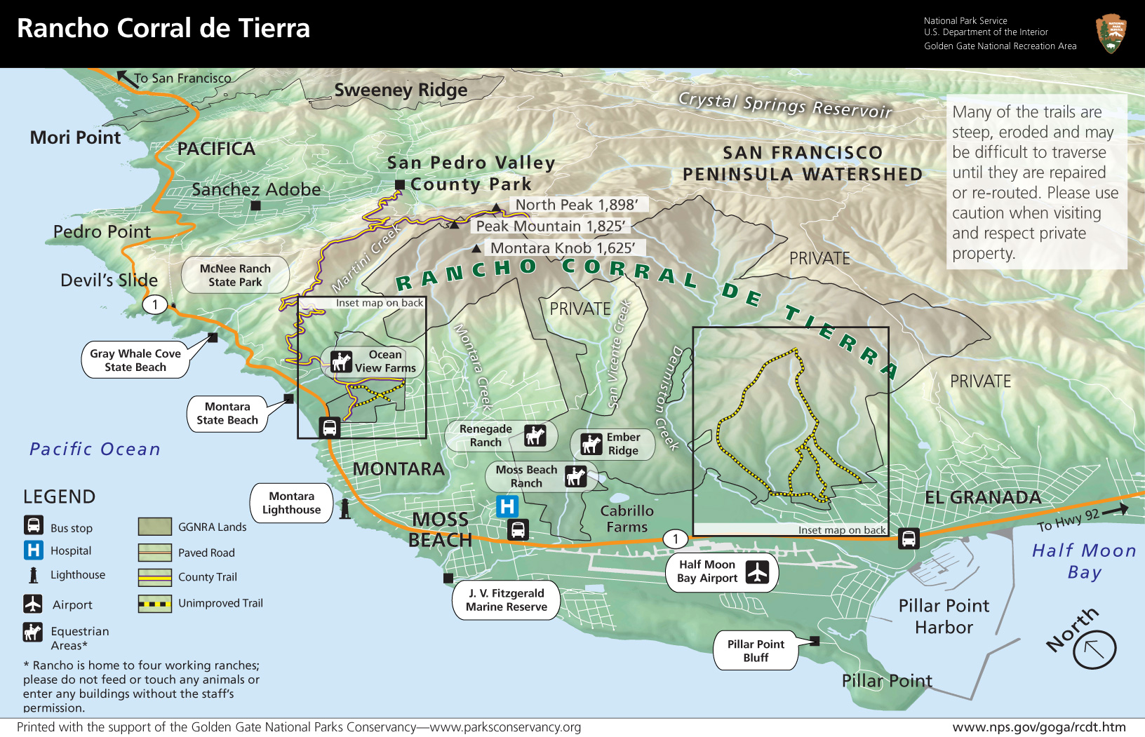
On 16 Oct1839 the Governor "ad interim," Manuel Jimeno, granted Francisco 7766 acres [one square league] along the Pacific Ocean with Montara Mountain to the north, the first ridge of the coastal range to the east and El Arroyo de en Medio [in the middle, the place where cattle were rounded up for the annual rodeo] to the south. This grant was approved by the Departmental Assembly on May 22, 1840. Additional land was granted on 1 May 1844 by Governor Manuel Micheltorena and approved by the assembly 12 Jul 1845.  This stretch of land near Pillar Point was called El Corral de Tierra.  The name perhaps reflected the way the hills seemed to encircle it to form a great natural corral of earth, or perhaps the fact that the point itself was used as a corral by simply fencing off its narrow neck."(5)   Only half of El Corral de Tierra was granted to Francisco, the other half went to Tibucio Vasquez.

Land Case File 49 - Josepfa Haro de Guerrero El Corral de Tierra (4) 


Francisco did not live on his land, his home was in San Francisco near Mission Dolores.(6) Even when many Mexican land grant holders fled San Francisco to live on their grants during the Mexican American War, Francisco and his family remained in San Francisco.

Francisco died on 13 Jul 1851 at the age of 40.  The cause of death was a fractured skull caused by being beaten with a slungshot (bag of shot) by Francis LeBras, a Frenchman.(7)  LeBras was acquitted perhaps on the urging of others who had feared the testimony of Guerrero regarding land grants. The attack was investigated by a Vigilante Committee and in newspapers.  A Coroner's inquest was held on the 14 thru 16 Jul 1851. The site of the murder was the corner of Twelfth and Mission streets. In 1906 the first station of the Ocean Shore Railroad connecting San Francisco to the old coastal lands of the Guerrero Rancho was constructed on the same site.

Today there are many reminders of Francisco on the land.  In the Mission District lies Guerrero Street,  On the coast,  land is still surveyed and recorded in the old land grant system of Corral de Tierra Palomares rather than in the township system used by the United States Land office in most states west of Ohio.

Francisco was buried in the Mission Dolores graveyard, across the street from the family home. His estate probated on 27 Oct 1879 in San Francisco. (8)

Athough the estate filed a claim for Francisco's San Mateo County Rancho, it wasn't until 1866 that the Guerrero claim to El Corral de Teirra was finally patented by the federal government. Patent Book One pg 471 records the patent which is given to Josefa DeH Guerrero et all.

As late as 1911 the Guerrero Adobe still stood, but an effort by Coastsiders and the Univesity Museum at Stanford fell short of the $300 needed to save it from being disassembeled for its timber by it's owners.  Today the Francisco Guerrero y Palomares claim has become part of the Golden Gate National Recreation area.

Francisco Guerrero and Maria Josefa Silvera De Haro (see De Haro) were married on 4 Sep 1841 at Mission Dolores (9) and had the following children
  • Agustin (Hipolito) Guerrero, born 13 Aug 1842 and died 7 Jan 1882.
  • Julian Emeterio Guerrero was born on 16 Feb 1844 and died 18 Mar 1844.
  • Nicolas Ramon Guerrero was born on 10 Aug 1846 and died in Jun 1848.
  • Victoriano William Guerrero, born abt 23 Dec 1848 and died 29 Aug 1928.
  • Francisco Macedonio Guerrero was born on 12 Sep 1851and died in Feb 1853.

For more information see

La Peninsula - Summer 2011 SMCHA

_________________________________________________________ 
1.   Information provided by Julie Christy , e-mail 10/10/2000.
3.   Brown, John Henry, Reminiscences and Incidents of the Early Days of San Francisco. San Francisco (SF:  Mission        Journal Publishing Co., 1886.)
4.   United States. District Court (California : Northern District). Land case. 49,  [1837] UC Berkeley, Bancroft Library
5.   Stanger, Frank M, South From San Francisco: San Mateo County California Its History and Heritage (San Mateo County Historical Association 1963), pg 41.
7.   Alta California; San Francisco Chronicle, June 20, 1911 "Working to Save Historic Adobe, to prevent ruin of old Guerrero Home, fine specimen of Spanish Architecture can be had for $300."
8.   SM - Official Record Books.
9.   Information provided by Julie Christy  


Wednesday, November 25, 2015

San Mateo County Places - West Union

West Union Creek is a 4.5-mile-long stream originating on the east slope of Kings Mountain  and flowing down to the valley formed by the San Andreas Rift where it turns near the Phleger Estate to flow southeasterly on an unusually level course (for a mountain stream) to Adobe Corner in the town of Woodside where it joins Bear Gulch Creek, which in turn flows to San Francisquito Creek and ultimately, San Francisco Bay. (Description from National Park Service)

The origin of the name "West Union Creek" is attributed to Willard Whipple who named it "Union Creek".  He established two mills along the creek that he intended to call East Union and West Union. Those designations did not take, the mills being called instead  Whipple's Upper and Whipple's Lower Mill.  The upper mill was more widely known and the area around it was soon designated West Union. The Upper Mill was located in a direct line from today's Whipple Road.

Golden Gate National Parks Trail Map - Phleger Estate
Showing Whipple's Upper Mill just north of Phleger Estate

San Mateo County Times Gazette reported on 7 Mar 1885  "A little village of about a dozen houses was formed on the banks of the headwaters of San Francisquito Creek. This little burg, taking its name from that part of the county in which it existed, was called West Union. Its inhabitants, of which there were few, consisted mainly of the millhands in the surrounding hills. Close by, cosily nestled in the woods, was the village burial ground, composed of about a half dozen graves of the victims of accidents in the woods and others.  ........The village has entirely disappeared and in the place of the adjoining graveyard can now be seen broad acres of farm land."

The San Mateo County Times Gazette reported on 11 Dec 1886 that ..... 

"Years ago a little cemetery was located at West Union some fives miles north of Woodside...Only one body has been removed from the cemetery...Alexander MacDonald...The land has come into possession of some Italians who desire to use the property as part of a vineyard." 

Alden Tagg in his Norcal-L  posting 10 Oct 1997 states "The cemetery I have a hunch was west of Canada Road, perhaps a bit south of the school site."  (see San Mateo County Places: West Union) 

West Union School circa 1910
A school was established in the area.  In a post to Norcal-L on 10 Oct 1997 Alden Tagg notes "... the USGS/GNI does not show a West Union, however the Woodside 7.5 quadrangle does.  I guess no one's perfect. West Union Creek runs about 1/2 mile west of Canada Road andcomes down from the hills running NE then turns SE to run into Bear Gulch Creek south of Woodside Road. The West Union School was NNE of where the WU Creek bends from NE to SE, about 1/2 mile south of Edgewood Road a bit east of Canada Road. Hwy 280 runs through the old school property."

There were 72 students when the San Mateo County Gazette reported on 22 Oct 1859 ......

MYSTERIOUS DISAPPEARANCE – On the first day of July last, J.H. Pratt, Esq., who had been for some time engaged as teacher of the school at West Union, in this county, drew from the county treasury, one hundred and sixty two dollars, and two days afterwards started for San Francisco, since which time he has not been heard from. He was to have been absent but a few days, and was to have reopened his school after a short vacation. Mr. Pratt was temperate and regular in his habits, and his long-continued absence has created considerable uneasiness on the part of his friends. Fears are entertained that he has met with foul play. All his clothing and effects were left as usual – he having taken nothing with him except the clothing he wore at the time, and his money. He had recently purchased some land in Petaluma, and went to San Francisco to make a payment on it. We had a conversation with him just before he left, in which he stated that he should be absent but a few days, that he expected his wife out soon from the East, and intended to make this county his home. We do not know what State he came from. He was recently admitted to the bar in the District Court of this county, upon a certificate from the Supreme Court of Ohio. He was a rather short, thick-set man, sandy complexion, slightly bald, and about thirty-five years of age.

In Nov 1860 the school house was the site of county elections with  George F. Maynard serving as Inspector and  Robt. Greer and James Berry as Judges.  San Mateo County Gazette 6 Oct 1860

A petition dated 4 Nov 1861 stated, " The West Union (School) District shall be founded as follows, to wit; Commencing at the SE corner of the Wolf Ranch; thence West along the south lines of the lands of M Wolf and John Claffey to the point nearest the center of Sec 30 T 5 S R4W; thence to NE corner of the NQ quarter of Sec 9 T6 S R5W; thence East to the SW corner of the Home Farm; thence along the West line to the NW corner of said farm; thence to the SE corner of the Wolf Ranch. taking in Williams and Danl Ross to the old Watter Mill and to the Ride of the Mountain"

Signing the petition were: Robert Greer, OS Payne, Thomas Knights, Samuel Walker, Sylvester Waker
SH Snyder, M Erickson, Ales Little, Michael G Kelly, Jeremiah Conroy?, James Duffy, Edward Donnelly, Andrew McCormac, John Hanley, John S Richards, Michael McLaughlin, John Regan, Benjamin Ross, Michael Surrill ?, John Butte (Burke), Alex Stott, A S Bonen, Charles Hill

By 1920 only three students remained in the district and Superintendent Roy Cloud requested a temporary suspension.

Among those born in West Union was James V. Swift. Antone Scada and  Amada Valdes are listed in James Crowe's Death book as dying there and John Tomalis is listed in the Early Death Records.

West Union Creek Bridge
Sawmills in the Redwoods: Logging on the San Francisco Peninsula 1849-1967 Frank Stanger
The Town of West Union - John Edmunds